
The Land
Southwest Anderson Plain
(in detail)
(Part 1)
by
Jean-Luc Pilon
NOGAP Archaeologist
Canadian Museum of Civilization
Research Area
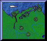
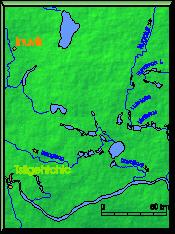
For the purposes of this discussion, the Mackenzie Valley is defined as that portion of the Mackenzie River lying below Norman Wells and the lands adjacent to it. It includes most of the Mackenzie Delta, although the outer Delta belongs more properly in the Beaufort Sea region. We could not cover the entire region but chose instead to concentrate on the uplands which form the headwaters of a number of streams draining the southwest portion of the Anderson Plain, lying east of the Mackenzie Delta. The area will hereafter be referred to as the southwest Anderson Plain, following Bostock (1964:19). However, we also conducted surveys in the Peel Plain Uplands to the south and in the Inuvik area to the west.Physiography
 The southwest Anderson Plain is comprised of three physiographic
sectors (Ritchie 1984). The first is designated the
Hyndman Lake Uplands (Mackay's Hyndman
Lake Hills Region VIII (1974:146)). The area encompasses the large lakes
which constitute the headwaters of the Kugaluk River, the Travaillant River, an
un-named tributary stream of the Iroquois River and the Rengleng River.
It is characterised by a hilly terrain with elevations reaching more
than 500 m asl and very well-defined
glacial melt-water channels. The
Inuvik-Anderson River Plains is a physiographic sector which lies to the north and west of the Hyndman
Lake Uplands. It is marked by lower glacio-fluvial features. The last
major physiographic sector lies along the Mackenzie River and is a low
plain, part of the Peel Plain Lowlands.
The southwest Anderson Plain is comprised of three physiographic
sectors (Ritchie 1984). The first is designated the
Hyndman Lake Uplands (Mackay's Hyndman
Lake Hills Region VIII (1974:146)). The area encompasses the large lakes
which constitute the headwaters of the Kugaluk River, the Travaillant River, an
un-named tributary stream of the Iroquois River and the Rengleng River.
It is characterised by a hilly terrain with elevations reaching more
than 500 m asl and very well-defined
glacial melt-water channels. The
Inuvik-Anderson River Plains is a physiographic sector which lies to the north and west of the Hyndman
Lake Uplands. It is marked by lower glacio-fluvial features. The last
major physiographic sector lies along the Mackenzie River and is a low
plain, part of the Peel Plain Lowlands.
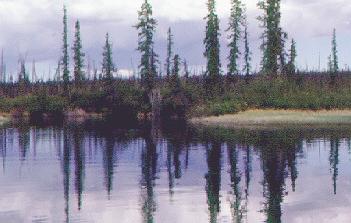
Evolution of the Landscape
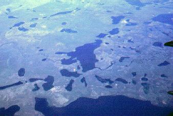
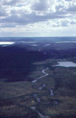
Late Pleistocene ice covered virtually all the southwest Anderson Plain (Prest 1970:741-42, Fig.XII-15). The glacial limit dating to 13,000 years ago, the Tutsieta Phase, was not as extensive as the glacial maximum which "occurred either between 18 and 30 KaBP or 70 to 110 KaBP" (Rampton 1987:23). Whatever the dating of the glacial maximum, it remains that the landscape of most lac ŕ la Truite, Tenlen Lake, lac au Goéland and the Kugaluk River was formed much earlier than areas to the south. Similarly, much of Jiggle Lake, Deep Lake, the eastern portion of Bathing Lake and all of Sandy Lake were not covered with ice during the last ice advance. Instead, these ice-free areas were occupied by interconnected glacial lakes which drained into the Kugaluk River system. These lakes formed distinct high elevation benches. Lower benches, usually a few meters above the present lake levels may indicate the irregularity of the drainage of these lakes and the effects of isostatic rebound.Deglaciation occurred very rapidly in the northwestern portion of the Laurentide Ice Sheet. Beget (1987) has suggested that the ice may have been comparatively thin over the region such that melting occurred downward and thus disappeared over a large area quite rapidly rather than melting inward toward an ice centre. In any event, deglaciation took place between approximately 11,000 and 9,000 years ago (Hughes 1969:7-10). The region's landscape thus assumed its present appearance by at least 9,000 BP.
 Palynologic studies effected to the north in the Eskimo Lakes and
in the northern Mackenzie Delta indicate that revegetation was a fairly
rapid process (Mackay and Terasmae 1963). In the Travaillant Lake area,
the oldest pollen assemblage is dominated by dwarf birch between 10,500
and 9,000 BP (Ritchie 1984:99). The second pollen zone spanning the
period from 9,000 to 5,500 BP, although still dominated by birch, sees
the addition of spruce, poplar and later juniper. Modern vegetation
patterns had implanted themselves in the Travaillant Lake area by 5,000
years ago.
Palynologic studies effected to the north in the Eskimo Lakes and
in the northern Mackenzie Delta indicate that revegetation was a fairly
rapid process (Mackay and Terasmae 1963). In the Travaillant Lake area,
the oldest pollen assemblage is dominated by dwarf birch between 10,500
and 9,000 BP (Ritchie 1984:99). The second pollen zone spanning the
period from 9,000 to 5,500 BP, although still dominated by birch, sees
the addition of spruce, poplar and later juniper. Modern vegetation
patterns had implanted themselves in the Travaillant Lake area by 5,000
years ago. 


